Effect of atmospheric turbulence on imaging quality of high-resolution remote sensing satellites
-
摘要:
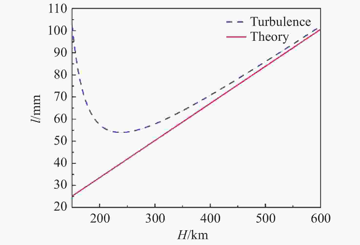
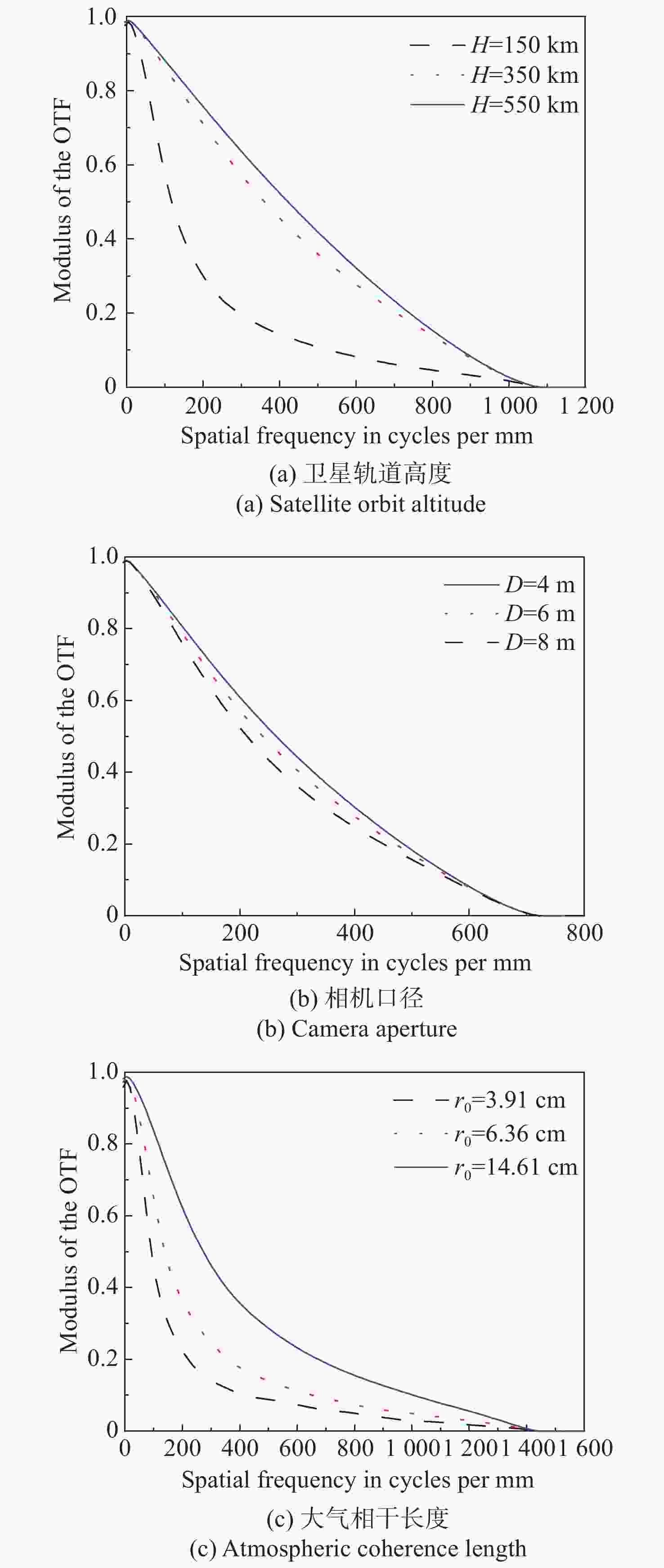
遥感卫星在国防和民用探测等领域发挥着重要作用,而大气湍流严重影响高分辨率遥感卫星的成像质量。本文重点研究了遥感卫星对地探测时,相机口径、卫星轨高和大气湍流强度对空间相机成像质量的影响。首先,基于球面波传输模型和Kolmogorov湍流理论,针对空对地探测湍流波前进行仿真。然后,分析畸变波前随相机口径、卫星轨高和大气相干长度的变化规律,并推导出普适公式。在此基础上,进一步推导出空间相机成像分辨率随相机口径、卫星轨高和大气相干长度变化的计算公式。最后,研究了大气湍流对空间相机调制传递函数(MTF)的影响,并以MTF=0.15为基准,仿真分析了MTF相对误差随相机口径、卫星轨高和大气相干长度的变化规律。本研究为高分辨率遥感卫星的设计、分析和评估提供理论依据。
Abstract:Remote sensing satellites play a crucial role in both national defense and civil exploration. However, the imaging quality of high-resolution remote sensing satellites is significantly affected by atmospheric turbulence. We focus on the impact of camera aperture, satellite orbit altitude and atmospheric turbulence intensity on the imaging quality of space cameras during remote sensing satellite earth detection. Firstly, the turbulence wavefront simulation method based on the spherical wave model and Kolmogorov turbulence theory is analyzed. Subsequently, the disturbed wavefront, impacted by the camera aperture, satellite orbit height and atmospheric turbulence intensity, is analyzed, and a universal formula is derived. In addition, an equation for imaging resolution with camera aperture, satellite orbit height and atmospheric coherence length is developed. Finally, the effect of atmospheric turbulence on the Modulation Transfer Function (MTF) is studied. The variation of the relative error of MTF with camera aperture, satellite orbit height and atmospheric coherence length is simulated and analyzed, with reference to an MTF value of 0.15. This study provides a theoretical basis for designing, analyzing, and assessing high-resolution remote sensing satellites.
-
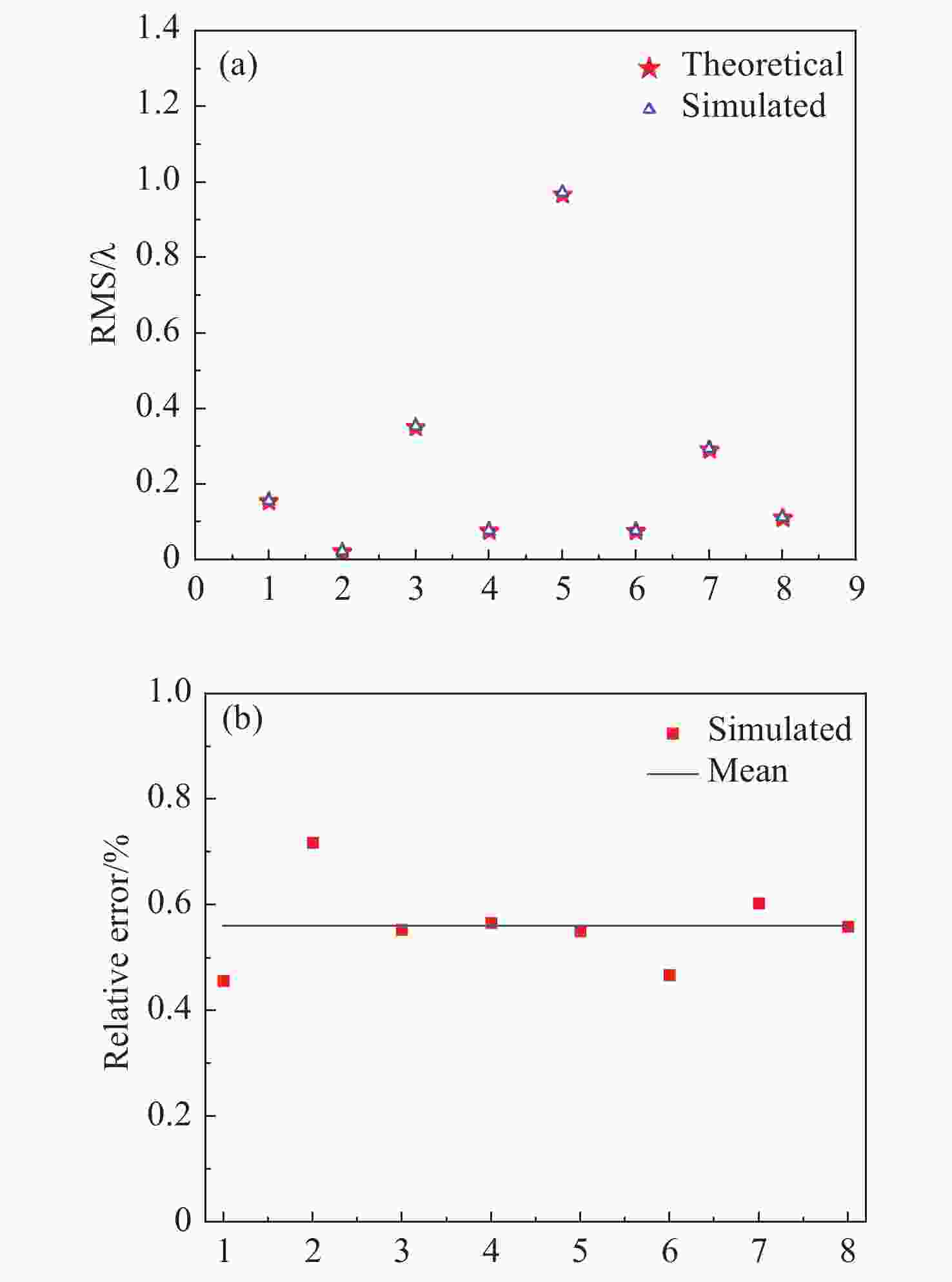
表 1 随机选取的变量
Table 1. Randomly selected variables
1 2 3 4 5 6 7 8 D/(m) 2 2 4 4 6 6 8 8 H/(km) 200 500 150 250 100 350 150 600 r0/(cm) 3 8 4 9 5 7 10 2 -
[1] WANG H B, GONG X SH, WANG B B, et al. Urban development analysis using built-up area maps based on multiple high-resolution satellite data[J]. International Journal of Applied Earth Observation and Geoinformation, 2021, 103: 102500. doi: 10.1016/j.jag.2021.102500 [2] 苏云, 葛婧菁, 王业超, 等. 航天高分辨率对地光学遥感载荷研究进展[J]. 中国光学(中英文),2023,16(2):258-282. doi: 10.37188/CO.2022-0085SU Y, GE J J, WANG Y CH, et al. Research progress on high-resolution imaging system for optical remote sensing in aerospace[J]. Chinese Optics, 2023, 16(2): 258-282. (in Chinese) doi: 10.37188/CO.2022-0085 [3] MU Q Q, CAO ZH L, LI D Y, et al. Adaptive optics technique to overcome the turbulence in a large-aperture collimator[J]. Applied Optics, 2008, 47(9): 1298-1301. doi: 10.1364/AO.47.001298 [4] 曹宗新, 曹楠, 杨燕燕, 等. 大气湍流对高分辨率遥感卫星定位精度的影响分析[J]. 中国光学(中英文),2023,16(3):550-558. doi: 10.37188/CO.2022-0196CAO Z X, CAO N, YANG Y Y, et al. Effect of atmospheric turbulence on the tracking accuracy of high-resolution remote sensing satellites[J]. Chinese Optics, 2023, 16(3): 550-558. (in Chinese) doi: 10.37188/CO.2022-0196 [5] TYSON R K. Principles of Adaptive Optics[M]. 3rd ed. Boca Raton: CRC Press, 2010: 25-36. [6] FRIED D L. Optical resolution through a randomly inhomogeneous medium for very long and very short exposures[J]. Journal of the Optical Society of America, 1966, 56(10): 1372-1379. doi: 10.1364/JOSA.56.001372 [7] KOLMOGOROV A N. Dissipation of energy in the locally isotropic turbulence[J]. Proceedings of the Royal Society Series A: Mathematical, Physical and Engineering Sciences, 1991, 434(1890): 15-17. [8] FRIED D L. Limiting resolution looking down through the atmosphere[J]. Journal of the Optical Society of America, 1966, 56(10): 1382-1384. [9] HUFNAGEL R E, STANLEY N R. Modulation transfer function associated with image transmission through turbulent media[J]. Journal of the Optical Society of America, 1964, 54(1): 52-60. doi: 10.1364/JOSA.54.000052 [10] 阎吉祥, 俞信. 大气湍流对遥感系统分辨力的影响[J]. 光学技术,2004,30(1):68-69. doi: 10.3321/j.issn:1002-1582.2004.01.032YAN J X, YU X. Effect of the turbulence on the image resolution of the remote sensing system[J]. Optical Technique, 2004, 30(1): 68-69. (in Chinese) doi: 10.3321/j.issn:1002-1582.2004.01.032 [11] 张晓芳, 俞信, 阎吉祥. 大气湍流对光学系统图像分辨力的影响[J]. 光学技术,2005,31(2):263-265. doi: 10.3321/j.issn:1002-1582.2005.02.029ZHANG X F, YU X, YAN J X, et al. Influence of atmospheric turbulence on image resolution of optical sensing system[J]. Optical Technique, 2005, 31(2): 263-265. (in Chinese) doi: 10.3321/j.issn:1002-1582.2005.02.029 [12] 王仁礼, 郝振纯, 陈波, 等. 大气湍流对天基遥感系统地面分辨率的影响[J]. 测绘科学技术学报,2009,26(2):114-117. doi: 10.3969/j.issn.1673-6338.2009.02.010WANG R L, HAO ZH CH, CHEN B, et al. Effect of Atmospheric turbulence on image ground-resolution of space-based remote sensing system[J]. Journal of Geomatics Science and Technology, 2009, 26(2): 114-117. (in Chinese) doi: 10.3969/j.issn.1673-6338.2009.02.010 [13] 陈欣欣, 苑克娥, 时东锋, 等. 大气湍流对空基光学成像系统影响的仿真研究[J]. 光学学报,2022,42(18):1801002. doi: 10.3788/AOS202242.1801002CHEN X X, YUAN K E, SHI D F, et al. Simulation study on the effect of atmospheric turbulence on space-based optical imaging system[J]. Acta Optica Sinica, 2022, 42(18): 1801002. (in Chinese) doi: 10.3788/AOS202242.1801002 [14] RODDIER F. The effects of atmospheric turbulence in optical astronomy[J]. Progress in Optics, 1981, 19: 281-376. [15] 周仁忠. 自适应光学[M]. 北京: 国防工业出版社, 1996: 24-28.ZHOU R ZH. Adaptive Optics[M]. Beijing: National Defense Industry Press, 1996: 24-28. (in Chinese) [16] 曹青华. 光束通过湍流大气干涉的初步探讨[D]. 成都: 电子科技大学, 2006: 15.CAO Q H. Preliminary discussion on interference of light beams through turbulent atmosphere[D]. Chengdu: University of Electronic Science and Technology, 2006: 15. (in Chinese) [17] NOLL R J. Zernike polynomials and atmospheric turbulence[J]. Journal of the Optical Society of America, 1976, 66(3): 207-211. doi: 10.1364/JOSA.66.000207 [18] RODDIER N A. Atmospheric wavefront simulation using Zernike polynomials[J]. Optical Engineering, 1990, 29(10): 1174-1180. doi: 10.1117/12.55712 [19] 王凯迪. 大气湍流波前畸变的自适应光学校正技术研究[D]. 西安: 中国科学院大学, 2021: 37.WANG K D. Research on correction technology of wavefront distortion from atmospheric turbulent by adaptive system[D]. Xi'an: University of Chinese Academy of Sciences, 2021: 37. (in Chinese) [20] TYLER D W, PROCHKO A E. Adaptive optics design for the advanced electro-optical system[R]. Albuquerque: Rockwell International Corp, 1994: 32. -


 下载:
下载:
